Archaeologists from the University of Exeter have unearthed an extensive Roman road network that spanned the regions of Devon and Cornwall, connecting significant settlements with military forts across the two counties.
 The full network of Roman roads in South West Britain. Credit: Parcero-Oubina et al., Journal of Computer Applications in Archaeology, 2023
This intricate network, linking not only local territories but also reaching wider Britannia, has been revealed through the use of advanced geographical modeling techniques, including laser scans from the Environment Agency’s National LiDAR Programme. The findings have the potential to reshape our understanding of the Roman road infrastructure in southern Britain.
For over 70 years, published maps of the Roman road network in southern Britain have remained largely unchanged, suggesting limited evidence for a system of long-distance roads west of Exeter, the Roman Isca.
However, the recent availability of comprehensive LiDAR coverage for Britain has transformed the scope of research into the Roman road network’s development within the province, particularly in the southwestern counties inhabited by the Dumnonii people.
Dr. Christopher Smart, an archaeologist at the University of Exeter, emphasized the significance of this breakthrough, stating, “The recent availability of seamless LiDAR coverage for Britain has provided the means to transform our understanding of the Roman road network that developed within the province, and nowhere more so than in the far southwestern counties, in the territory of the Dumnonii.”
The research, conducted in collaboration with Dr. João Fonte and other specialists in landscape archaeology and geospatial technologies, has brought to light sections of the road previously uncharted. This discovery reveals that North Tawton played a pivotal role in connecting vital areas through the Roman road network, suggesting a more intricate and strategic system than previously believed.
The Geographic Information System (GIS) predictive model developed by the researchers was key in filling gaps in the existing knowledge about the network’s layout. By applying methods such as Least Cost Paths, focal mobility networks, and transit corridors, the team identified primary and secondary nodes across Devon and Cornwall. These nodes encompᴀssed not only well-known military forts like Old Burrow and The Beacon at Martinhoe but also settlements such as Exeter and North Tawton.
The researchers’ findings imply that the Roman road network was a complex amalgamation of pre-existing Prehistoric routes, Roman military campaign roads, and civilian roads constructed during peacetime. This evolutionary model is supported by the network’s connections that extended beyond military supply routes, suggesting broader societal and logistical purposes. The Roman road network’s primary intent appears to have been to facilitate the movement of animal-drawn vehicles and circumvent areas prone to flooding.
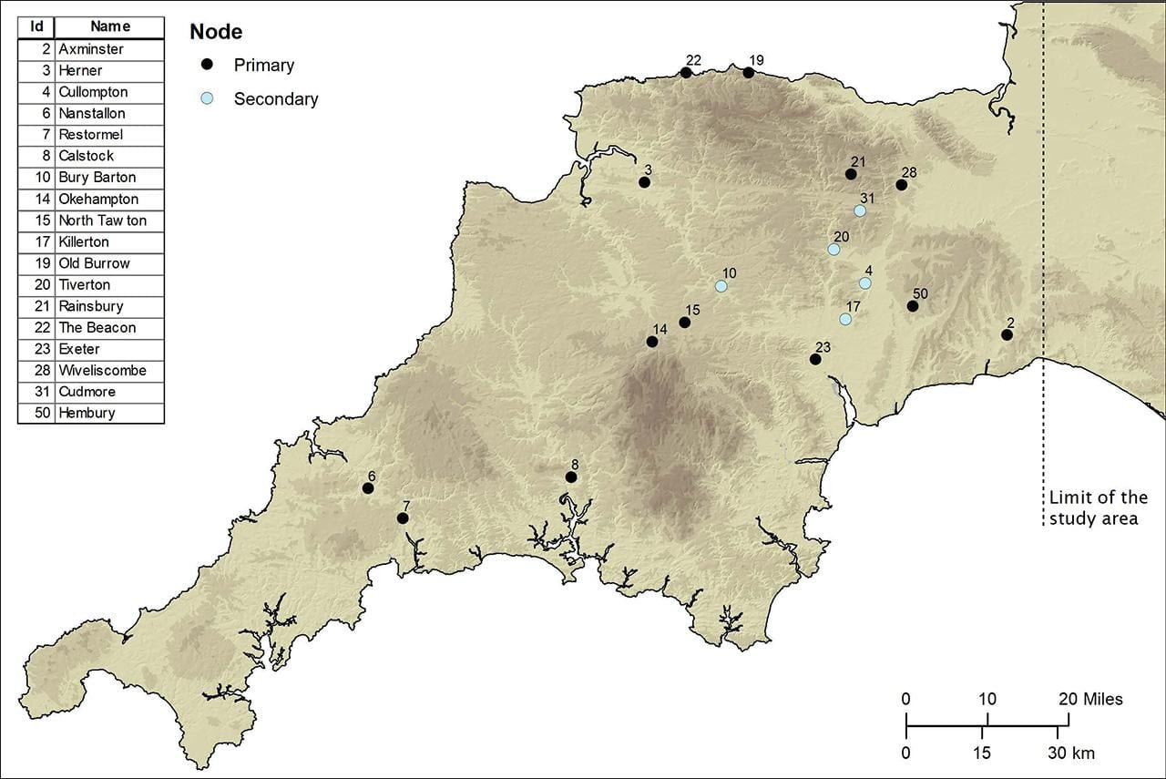 Primary and secondary nodes in the study area. Credit: University of Exeter
This innovation not only enabled better connectivity between settlements but also suggests the possibility of previously unknown settlements yet to be discovered. Dr. Smart further highlighted the implications of this discovery for future archaeological research, stating, “This network, identified by the scans and the GIS-enabled modeling, may serve to predict the location of settlements that are as yet unknown to us.”
The research, documented in the Journal of Computer Applications in Archaeology, showcases the remarkable engineering prowess of the Romans and the ways in which their road infrastructure influenced settlement patterns and societal connectivity.
More information: Cesar Parcero-Oubina et al, (2023). Remote Sensing and GIS Modelling of Roman Roads in South West Britain, Journal of Computer Applications in Archaeology. DOI: 10.5334/jcaa.109


